Monthly Archives: November 2018

A better day in Tideswell

Friday was a much more pleasant day in the Peak District. Broken cloud allowed sunny periods every where. There were a few showers around but in Tideswell we managed to miss them all. It was a cooler day with a max temp in Tideswell of 7.4° and there was a cool breeze. Nevertheless, it was a splendid day for outdoor activities.

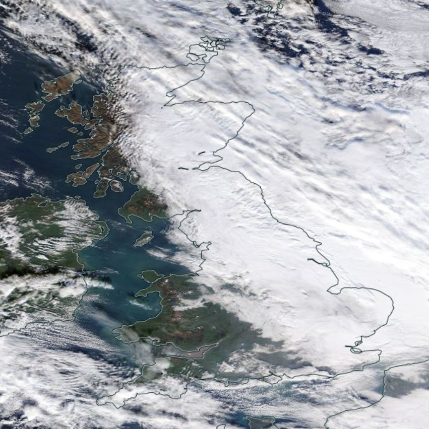
The satellite image below shows the situation in the middle of the day, with the greater part of England almost cloud-free. Skies were mostly cloudy just north of the Peak District but we were fortunate and remained in the sunnier conditions.

Broken cloud

Over the next few days the very changeable weather will continue in the Peak District. On Saturday morning there’ll be a spell of wet weather and another on Sunday morning. Outside of these spells there’ll be more broken cloud and showers.

On Tuesday night and into Wednesday morning a low pressure centre is expected to move E or NE across the British Isles. If this low centre passes to the south of the Peak District it is possible that we could have a spell of sleet or snow. This is far from being a certainty and if it does happen the snow would be of the ‘here today, gone tomorrow’ variety.

Looking further ahead, there are some hints from the computer models that we could be in for some rather colder weather towards the middle of December. It’s still too far ahead to have any confidence in the model predictions but the possibility is there.

Wet and windy this morning – a bit better later in the day

It was a wet and windy morning over the Peak District today with SSE gales in exposed parts, especially at higher levels. In Tideswell the wind got up to Force 7 with a maximum gust of 53 m.p.h.

Towards the end of the morning a sharply-defined cold front swept quickly east across the Peak District. This show up well on the following satellite image from the middle of the day. The shadow of the high cloud is clearly visible over southern England and the English Channel.

Cold front


In Tideswell, the cold front went through at about 11:30 a.m. accompanied by a brief burst of torrential rain with a max rate of 80 mm/hr. There was a sharp fall in temperature as the front went through, followed by a more gradual fall. The first part of the afternoon was dry with a few short sunny intervals but later in the afternoon it became showery and the showers became increasingly heavy into the evening.

Temperature

For the forseeable future (i.e. up to about a week ahead) it looks like we shall be stuck in a run of very unsettled weather with a succession of fronts and low pressure centres moving in from the Atlantic. These will bring spells of mild, wet and windy weather alternating with spells of colder, showery weather across the Peak District. Very changeable will sum it up very well. There’s no sign of anything particularly cold but it is possible that we may see a short spell of wintry precipitation above 250-300m during Tuesday night and Wednesday morning.

Beyond next week is very uncertain but there’s currently no sign of the changeable weather coming to an end and no sign of anything notably cold.

Unsettled and windy

Not a very nice day in Tideswell today. There was slight to moderate rain and drizzle for most of the time with only one or two brief dry interludes. It was a windy day with the SSE wind peaking at Force 6 in the early afternoon with a max gust of 48 m.p.h. It was a very mild day, though, with a max temp in Tideswell of 11.7°.

Temperature

There’s a bit of a lull in the weather now but there’s a storm brewing for Thursday morning. The satellite image below shows a mass of cloud  to the west of the Iberian Peninsula. This is a developing low pressure centre that’s headed our way for Thursday.

Satpic

This low will run rapidly NE and deepen, probably crossing the British Isles during tomorrow. It’s likely to bring very strong S-SW winds across much of England and Wales during daytime on Thursday. In Tideswell we could see gusts as highas 50-60 m.p.h. on Thursday morning. That’s stronger than anything we had on Wednesday. More unsettled weather is expected through till the weekend.

The animation below shows the expected developments over the next 30 hours or so.

Arpege


A very unsettled week ahead

Tuesday began with thick fog in Tideswell. As the SE wind freshened this lifted into low cloud and, although the morning stayed dry, it became decidedly raw in the strengthening wind with the temperature only just creeping up to 3°.

Slight rain started around 1230z and as the intensity increased it turned to moderate sleet just after 1300z. The sleet carried on until about 1345z but then, with the temperature just creeping up, it turned back to rain. We then had moderate to heavy rain till about 1730z. After the rain ceased we have gone back to thick fog and slight drizzle. The current (2030z) temperature is 5.1° and that’s the highest it has been all day.

The satellite image below, from the middle of the day, shows the cloud from the frontal system over the  the country and a great mass of cloud to the SW heralding another wet and wind day tomorrow.

Nasa worldview


Over the next week Atlantic weather systems will dominate our weather. In Tideswell we’ll see spells of wet and very mild weather alternating with spells of brighter and somewhat cooler weather but it’s almost impossible to put any sort of  reliable detail on the predictions. One thing that does look pretty certain is that tomorrow (Wednesday) will be particularly windy. Even in Tideswell, which is relatively sheltered, we may well see southerly winds gusting to over 50 m.p.h.. For the following few days the wind will be a significant feature of the weather.

The first animation below shows a prediction of the evolution of the weather systems over the next 5 days.

The second animation shows one computer model’s idea of the accumulating precipitation over the next 16 days. This indicates well over 100 mm in the Peak District.

The detail shown in these animations cannot be relied on but they do indicate a lengthy spell of very unsettled weather which will often be mild and will be largely frost-free.

Icon

Rainfall

Here comes the change

The precipitation is sweeping into the country from the SW this morning as the animation below shows.

1811270830

The current temperature in Tideswell ( 9:00 a.m.) is 2.3° so it is probable that the precipitation will start as sleet or wet snow over higher parts of the Peak District around the middle of the day. SE winds are freshening quickly and will become strong in exposed parts this afternoon.

One final cold night

Monday turned out a splendid day in the Peak District. After a little rain just before dawn the cloud soon broke up and we had a day of broken cloud and sunny periods with only a light breeze. It turned out to be the best day for outdoor activities for some time. In Tideswell 2.6 hours of sunshine were measured, making it the sunniest day since Sun 26th Nov.

With some cloud clearances this evening sharp dips in temperature are starting to occur as the graphic below shows.

Temperature


Big changes are afoot for tomorrow as an active low pressure system approaching the British Isles from the Atlantic pushes rain and strong winds rapidly eastwards  across the country. This is expected to reach the Peak District during the early afternoon and with cold air still in place there may be snow for a time at high levels. In Tideswell we may see a short spell of sleet or wet snow. However, any snow will turn to rain later as temperatures rise.

During the remainder of this week very unsettled weather is expected and it will be wet and windy at times. During Wednesday southerly winds may gust to more than 50 mph in Tideswell and in exposed areas higher up gusts will be much stronger.

There are some hints that next week may see a gradual change back to colder weather but this is uncertain at present.

The animation below shows the predicted accumulation of rainfall over the next 5 days. Given the very dynamic nature of the weather pattern this should be taken as indicative of the nature of the evolution rather than as a firm forecast.


Rainfall accumulation

The change is coming – on Tuesday

We’ve got another 40 hours or so of this quiet, rather cold weather with easterly winds and a few sprinkles of rain over the Peak District.

On Tuesday morning a vigorous low pressure area to the west of the British Isles will push an active frontal system into the country. Ahead of this front we’ll see strengthening SE winds over the Peak District. The precise timing is very uncertain but we’ll see an area of precipitation sweeping in, probably during late Tuesday morning. Over the highest parts of the Peak District this is likely to be of snow for a while. Even in Tideswell we could see a short spell of sleet or wet snow. However, temperatures will rise during the day and all of the snow will eventually turn to rain.

Wednesday and Thursday look likely to be very windy with further spells of rain. In Tideswell, southerly winds may well gust to more than 50 m.p.h. during Wednesday.

Very unsettled and often windy weather looks like persisting into next weekend, with the temperature easing down, bringing the possibility of wintry precipitation to the highest parts of the Peak District.

The animation below shows the predicted rainfall accumulation up until midday on Sunday. It predicts close to 50 mm accumulating in the Peak District so quite a wet few days.

UK rain

A change is on the way

Another quiet and rather cold day in Tideswell with the light NE wind persisting over the Peak District. The morning was gloomy and misty and there was a little rain from time to time. Around the middle of the day the lowest cloud dispersed and it became dry. Although the sky remained mostly cloudy it did get a bit brighter and we even saw a few short intervals of sunshine. It’s a few days since we saw any of that!

As is so often the case in easterly winds the best of any sunshine today was to be found in the West of Scotland. The first image below is a satellite image for the middle part of the day which clearly shows the cloud-free area over Western Scotland. The second image is a photo showing the moon in clear skies over the island of Harris in the Outer Hebrides this morning.

NASA Worldview


Moon over Harris


The quiet, rather cold weather is expected to continue over the Peak District over the remainder of the weekend and into the first part of next week. However, during Tuesday and Wednesday we are going to see a gradual change to much more unsettled and somewhat milder weather as vigorous low pressure systems approach the British Isles from the Atlantic. There is potential for a spell of very strong winds and widespread rain during Wednesday and into Thursday but the detail of this is still very uncertain.

Unsettled conditions with spells of wet and windy weather look likely to continue into the first week of December but there is a hint, and no more than that, of something more settled and colder developing by the middle of the month. At this stage, though, that’s highly speculative.

The animation below shows the predicted rainfall accumulation over the next two weeks. It’s based on one run of one computer model so the detail cannot be relied on. Nevertheless, it is indicative of the sort of weather that is likely to occur.


UK rain

A gloomy day in Tideswell

Friday was gloomy, overcast and misty in Tideswell with the visibility down into fog limits from time to time. The fog thickened in the evening. At least it was a dry day!

It wasn’t dry everywhere in the country, though. This morning’s radar loop (link below) shows that there were showers across Scotland and some quite hefty showers affecting SW England and Western Wales.

The midday satellite image (link below) shows that most of the country was cloud covered with only a narrow band of more broken cloud extending from the south of Northern Ireland, acoss Cumbria to Yorkshire giving some sunny spells in these areas. East Kent was also getting a bit of sun.

The third image (link below) shows the fog over Kinder Scout this evening, illuminated by the moon.

Radar loop

Midday satellite image

Fog over Kinder Scout illuminated by moonlight

Still cold but there’s a hint of a change to come

The day started very frosty in Tideswell with an overnight min temp of -3.2°. Before it rose above 0° it started to rain around 7:00 a.m. On the cold surfaces the rain immediately froze and resulted in extremely slippy conditions. The rain continued till about 8:15 a.m. but the last of the ice didn’t disappear till between 10:00 and 11:00 a.m. It was amongst the worst conditions we have had for some months and, of course, it wasn’t forecast. Forecasters without intimate local knowledge are on a hiding to nothing when faced with this sort of situation.

Th midday satellite image (below) shows that the western fringes were the most favoured today with only small amounts of cloud and long sunny spells. Central and eastern areas were inder a blanket of cloud.

Br Is satpic


In Tideswell, we had fog all day with slight drizzle from time to time. Mostly, the visibility was in the range 500-800m but the fog thickened up considerably after dusk with the visibility dropping to 100m.

It was another cold day in Tideswell with the temperature not getting much above 3°.

Temperature


For the remainder of this week, through the weekend and into the first part of next week it looks as though the Peak District will remain in relatively cold easterly winds. It’ll be mostly cloudy with some rain and drizzle from time to time but rainfall amounts will be small. Due to the cloud cover Tideswell will probably be frost-free.

There are hints from the computer models that in the middle of next week there might be a change to more changeable weather as low pressure systems push in from the Atlantic. If this does happen, the weather over the Peak District will become a bit milder with stronger SW winds and it’ll be more unsettled with spells of rain. This isn’t yet a certainty but it is an increasing probability and there is potential for spells of very wet and windy weather later in the week. Watch this space!

« Older Entries